Although it is possible to orienteer on almost any map, it 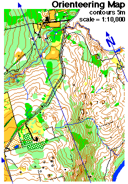 is
much more enjoyable to use maps made specifically for orienteering. Such
maps are accurate and detailed, and are prepared on a human scale - terrain
and features are mapped so that what appear s on the map are the features
that a human, moving through the area, sees readily. For example, boulders
that are waist high appear on orienteering maps.
is
much more enjoyable to use maps made specifically for orienteering. Such
maps are accurate and detailed, and are prepared on a human scale - terrain
and features are mapped so that what appear s on the map are the features
that a human, moving through the area, sees readily. For example, boulders
that are waist high appear on orienteering maps.
The orienteering map has evolved substantially over the last 50 years.
In the 1940s, events in Scandinavia used 1:100,000 (1 cm =1 km) government
issue maps, often in black and white and without contour lines to show
the shape of the land. Nowadays, most orienteering events are held on
five-color maps that have 5 meter contour intervals (16.5 feet) and have
a scale of 1:15,000 (preferred) or 1:10,000 (1 cm = 100 meters).
Most of the characteristics of orienteering maps are related to those found on hiking and general use maps produced by the government. However, one feature of orienteering maps is specific to the sport: the north lines. On the example shown here, they are drawn in blue (on many maps, they are black). North lines are parallel lines drawn running from magnetic south to magnetic north, and are spaced 500 meters apart on the map. Why aren't north lines on orienteering maps drawn pointing to true north? Because the angle between magnetic north and true north (the declination) varies widely in different parts of the world, and because orienteers use compasses to orient themselves (to magnetic north, not true north), it has become the standard to provide a series of reference lines on the map so that it is easy to use an orienteering compass to take a bearing.
There are international specifications for map symbols, and these have been successful in their aim of making orienteering map symbols standard throughout the world.
Some general rules for orienteering map symbols that make the system easier to understand
- Black is used for rock features (for example, boulders, cliffs, stony ground) and for linear features such as roads, trails and fences as well as for other man-ma de features (for example, ruins and buildings)
- Brown is used for landforms such as contour lines, small knolls, ditches, earthbanks.
- Blue is used for water features: lakes, ponds, rivers, streams, marshes.
- Yellow shows vegetation - specifically for open or unforested land. The density of the yellow color shows how clear the area is: brightest yellow for lawns, pale yellow for meadows with high grass.
- Green is used to show vegetation that slows down the passage of an orienteer. The darkest green areas, called "fight", are almost impassably overgrown.
- White on an orienteering map signfies forest with little or no undergrowth - forest that an orienteer can run through.
- Purple (or red) is used to mark the orienteering course on a map. Conditions that are specific to an event (such as out-of-bounds fields in which crops are growing) are also designated in red or purple.